Welcome to Oceanscope INDIGENOUS COMPANY
hydrographic and geophysical survey SOLUTIONS
Welcome to Oceanscope INDIGENOUS COMPANY
hydrographic and geophysical survey SOLUTIONS
Oceanscope Services Limited has access to a large pool of various positioning, geophysical and geotechnical equipment required to meet client’s specific need.
The company head office in Nigeria is adequately equipped for project support including ample workshop space for equipment maintenance.
Equipment List

The C-Nav3050 integrated C-Nav/RTK Extend Receiver provides decimeter-level position accuracy, anywhere in the world, anytime. This system is powered by the Sapphire GNSS Engine, the C-Nav3050 provides 66-channel tracking, including multi-constellation support for GPS, and GLONASS. It also provides patented interference rejection and anti-jamming capabilities.
The C-Nav3050 is fully upgradeable, allowing users to go from a single-frequency receiver, to multi-frequency with a simple software upgrade. The flexibility of the C-Nav3050 will enable you to adapt to any application, and will give you the confidence to get the job done.
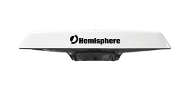
Now with GLONASS, the IMO Wheelmarked Vector™ V103™ and V113™ GNSS compass series is known for its superb heading and positioning performance. With the addition of GLONASS, the V103 and V113 now provides a more robust solution in critical areas where sky blockage occurs. The rugged IP69K design housing is sealed for the harshest environments. It incorporates fixed and pole mounting capability for both marine and land applications. The Vector V103 and V113 series is suitable for both dynamic positioning and professional marine surveys, as well as for machine control applications in agriculture, mining, construction, and other challenging applications.
The V103 and V113 utilize all of the recent innovations in Hemisphere’s Crescent® Vector GNSS technology. New Cross-Dipole low-multipath antennas are separated by 50 cm between phase centers, resulting in better than 0.3° heading performance while delivering position accuracy of better than 30 cm when using SBAS or Beacon corrections.
The Vector V103 and V113 support both NMEA 0183 and NMEA 2000 interfacing, enabling a seamless choice of communication protocols with Hemisphere GNSS’ messaging. Crescent Vector technology delivers accurate and continuous performance, including position, heading, heave, pitch, and roll. The stability and maintenance-free design of the Vector V103 and V113 series replaces traditional gyrocompasses and stand-alone GPS at a fraction of the cost.
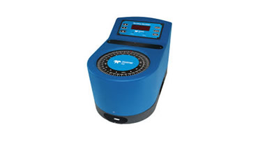
The Meridian gyrocompass product range is suitable for the ever-changing needs of a modern integrated bridge system. This includes highly accurate performance with low cost of ownership and system flexibility. Due to the Meridian’s small size and fast settle time of less than 45 minutes, there are no limits to the type of vessel for which it is suitable. The Meridian gyrocompass can be installed as a stand-alone unit or, together with any of the TSS range of repeaters and ancillaries, it becomes a single, dual or triple gyro system. The Meridian can also be used as a retrofit unit. For simple installation the Meridian offers a large array of digital and analogue outputs plus easy set-up and self-test modes that are activated via the control unit. The versatility and flexibility of the Meridian can be clearly demonstrated with the remote control unit option which gives freedom to install the main unit in the most convenient location whilst installing the remote control unit where it can be seen and regularly used. Unlike other marine navigation gyrocompasses available, the Meridian has a maintenance-free dry element with a meantime between failures of more than 30,000 hours: and post-installation there are no scheduled annual maintenance and servicing costs.
The heart of the Meridian gyrocompass is the element, which is a dynamically tuned gyroscope (DTG). The DTG is a high precision technology which, due to its size, accuracy, reliability and shock resistance, is used in many different applications. The guaranteed accuracy of the Meridian gyrocompass is obtained through specialized high quality engineering. This gives exceedingly stable heading and means that the gyro will follow a high turn rate of up to 200° per second.

HYPACK® is one of the most widely used hydrographic surveying packages in the world, with more than 10,000 users. It provides the Surveyor with all the tools needed to design their survey, collect data, process it, reduce it, and generate final products. Whether you are collecting hydrographic survey data or environmental data, or just positioning your vessel in an engineering project, HYPACK® provides the tools needed to complete your job. With users spanning the range from small vessel with just a GPS and single beam echosounder to large survey ships with networked sensors and systems, HYPACK® gives you the power needed to complete your task in a system your surveyors can master.
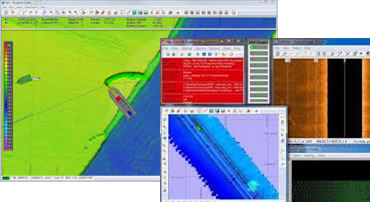
QINSy SURVEY is the complete version of QINSy and supports multiple objects and interfacing of many survey sensors. QINSy Survey is intended for more complex survey operations involving multiple vessels/vehicles and where backup sensors are widely used.
As multiple objects can be defined, QINSy Survey can be used for all types of offshore activities like anchor handling with tug management, pipe and cable lay operations, and of course ROV/AUV/Crawler operations. QINSy Survey comes with data acquisition, full survey planning, data cleaning and validation, data exchange and mapping. This version of QINSy can be customized with add-on modules like the MBES and SSS add-ons, plus Remote Display Control.
Accurate timing is critical in complex surveys and as part of its core design QINSy has always been able to use a timing routine based on the 1PPS option from GNSS receivers. For less time critical operations, it is able to utilize NTP time synchronization methods, or NMEA messages.
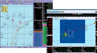
Navigation & positioning
NaviPac is the NaviSuite workhorse. It provides navigation information and positioning calculations in support of any offshore task. The display offers real time sensor and sonar data acquisition view, multiple waypoint view and run line tracking combined in a single display. It offers dedicated map and data views for offshore 2D seismic surveys. It allows for more efficient navigation and quality control in dedicated displays or via built-in tools using feather angle measurements, event distance statistics and enhanced EOL reports. It allows visualization of barge navigation with target placement, position and height of legs, and range/bearing to destination.
Navipac support more than 400 sensor drivers – with new ones being added as new technology is introduced – ensure that even the widest equipment spread is supported. This removes the need for combining several different equipment-specific software solutions and consequently also the risk of errors caused by working with different formats and interfaces. Features include:
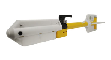
The model G-882 cesium-vapor marine magnetometer is a high performance instruments delivering high resolution results in all types of survey applications. The G-882 is a low cost, compact system designed for professional surveys in shallow or deep water.
The G-882 magnetometer’s digital output can be recorded with any serial data logger but its full potential is obtained when used with our MagLog Lite™ software to log, display and print GPS positioned measurement results. The price, performance and reliability of the G–882 make it the best value of any marine magnetometer available today. The G-882 is designed for operation from small vessels for shallow water surveys as well as for large survey vessels for deep tow applications (4,000 psi rating, telemetry over steel coax available to 10Km). Being small and lightweight (40 lbs net, no extra weights) it is easily deployed and operated by one person. Power may be supplied from a 24 to 30 VDC battery power or the included 110/220 VAC power supply. The standard G-882 tow cable includes a Vectran strength member and can be built to up to 700m (no telemetry required). The shipboard end of the tow cable is attached to an included junction box or optional on-board cable for quick and simple hookup to a power source. Output data can be recorded on any Windows 98, ME, NT, 2000 or XP computer equipped with RS-232 serial ports. Best of all, the rugged G-882 is designed for and has been used successfully everywhere in the world for all types of applications.
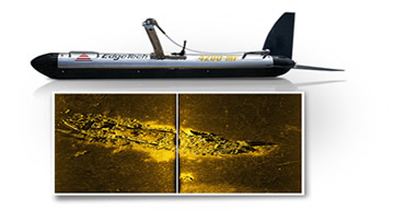
The 4200 Series is a versatile side scan sonar system that can be configured for almost any survey application from shallow to deep water operations. The 4200 utilizes EdgeTech Full Spectrum® CHIRP technology to provide crisp, high resolution imagery at ranges up to 50% greater than non-CHIRP systems; thus allowing customers to cover larger areas and save money spent on costly surveys.
One of the unique features of the 4200 is the optional Multi-Pulse (MP) technology, which places two sound pulses in the water rather than one pulse like conventional side scan sonar systems. This allows the 4200 to be towed at speeds of up to 10 knots while still maintaining 100% bottom coverage. In addition, the MP technology will provide twice the resolution when operating at normal tow speeds, thus allowing for better target detection and classification ability. The addition of the optional MP technology provides the operator with two modes of operation; either High Definition Mode (HDM) or High Speed Mode (HSM). This software- selectable mode of operation provides the operator the ability to select the best configuration for the specific job type.
All EdgeTech 4200 systems are comprised of a topside system and a reliable stainless steel tow fish. A choice of dual simultaneous frequency sets are available to the user and topside processors come in a choice of configurations from portable to rack mounted units. In addition, an easy-to-use GUI software is supplied with every unit.
Numerous additional sensors are also available for the 4200 including a fully integrated tracking system with built -in responder nose.
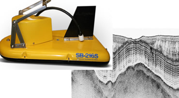
The 3100 is EdgeTech’s portable version of their highly successful sub-bottom profiler product line. The system utilizes EdgeTech’s Full Spectrum CHIRP technology which provides high resolution imagery of the sub-bottom structure at penetration up to 100m. /p>
The 3100 is ideally suited for use in rivers, lakes, ponds and shallow water ocean applications up to 300m max depth. The system was designed for customers that require a portable system that can be used from smaller boats while not wanting to sacrifice image quality.
A 3100 system comes with a choice of two towfish; either the SB-424 or SB-216S. These towfish operate at different frequency ranges and selection between the two depends on the type of application. The SB-424 operates at 4-24 kHz and will provide slightly higher resolution but less penetration. The SB-216S operates at 2-16 kHz and provides slightly less resolution but greater penetration. Along with a towfish, the 3100 system comes with a portable splash-proof topside processor with laptop computer running EdgeTech’s DISCOVER software for display of the sonar data. The system comes standard with a 35m tow cable with customer-specified lengths also available.
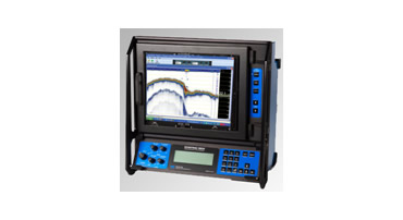
The Echotrac MKIII is the only sounder on the market offering you the choice of either a high resolution thermal paper recorder or a full-sized high bright color LCD chart in interchangeable module format. Both high and low channels feature frequency agility, enabling the operator to precisely match the transceiver to almost any existing transducer. This ability minimizes near-surface noise caused by transducer ringing while increasing echo return strength. The MKIII is capable of both shallow and deep water operations and features unsurpassed interfacing flexibility with four serial ports and high speed Ethernet capability for maximum efficiency.
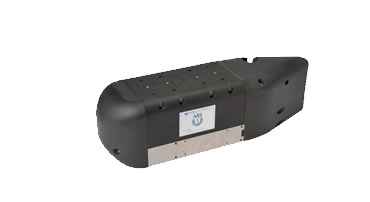
MB1 Multibeam Echosounder Completely designed and manufactured within the Teledyne Marine group, the MB1 Multibeam Echosounder is designed to meet the needs of hydrographic professionals that are looking for a low cost yet high performance swath sounder. Using both amplitude and phase bottom detection, MB1 is capable of sounding a swath of up to 120 degrees in over 120m depth of water, and up to 240m at nadir. With 24 bit resolution and a dedicated projector, both raw water column and seabed data can be collected within the controller software.
Using a new and improved Real Time Appliance (RTA), the echo sounder can be interfaced with all of the sensors necessary for surveying whilst maintaining accurate timing synchronization.
The sounder is manufactured using corrosion resistant Acetal and Titanium, ensuring years of reliable use in harsh marine environments. Impulse Titan series connectors are used for quick and dependable data connection.

SATELLINE-EASy is a new state-of-the-art transceiver radio modem providing a compact and flexible solution for many different long-range applications. SATELLITE-EASy is equipped with all necessary features; such as 90 MHz / 70 MHz tuning range (330…420 MHz / 403…473 MHz) in one hardware, selectable channel spacing and low power consumption either with +3…+9 Vdc or +6…+30 Vdc voltage level ranges. The configuration of the radio modem can be made with a terminal program or a Satel Configuration Manager.
SATELLINE-EASy is compatible with SATEL radio modules and high power products, and with SATEL additional equipment e.g. SATELLINK products.
SATELLINE-EASy can be equipped with a LCD and push buttons for facilitating the configuring of the radio modem.